By Will Cook
Overview: Another great birding spot near Falls Lake, this section of the extensive Butner Game Lands at the upper reaches of Falls Lake has an excellent variety of birds and habitats. Similar to the nearby Brickhouse Road and Flat River impoundments, this area is made up of a variety of habitats — bottomland hardwood forests, pine woods, swamps, and large fields with hedgerows — that harbor many bird species throughout the year. The fields have open skies for hawk-watching. In winter, this area abounds with sparrows: Song, Swamp, White-throated, Field, Chipping, Fox, Savannah, White-crowned (in descending order of abundance). The locally rare Lincoln's Sparrow has been found here on a couple of spring counts. The swampy areas are good for woodpeckers and warblers. Shorebirds are possible when fields are flooded by rains.
Getting there:
Interstate (good when coming from any direction):
Take Interstate 85 to Exit 189 (Butner)
Go northwest on Central Avenue (1103) through the center of Butner
Turn left on Veazey Drive
Follow Veazey Drive to end
Turn left on Old Oxford Highway (AKA Old 75 Hwy)
Continue for about a mile
The impoundment is on the left (look for the brown sign with the misspelled name "Knapp of Reeds Creek"), opposite the huge prison, the Butner Federal Correctional Complex.
Park in the gravel lot.
Birding route (good when coming from south or west):
Take Interstate 85 to Exit 177 (Roxboro Road).
Go north on Roxboro Rd for 1.5 miles.
Turn right on Old Oxford Highway (at Church's Chicken).
Follow Old Oxford Highway for 10.0 miles, passing the Flat River Impoundment at mile 8.0 and Brickhouse Road at mile 9.0
The impoundment is on the right (look for the brown sign with the misspelled name "Knapp of Reeds Creek"), opposite the huge prison, the Butner Federal Correctional Complex.
Park in the gravel lot.
Here's the address for finding it via Google Maps (you can even see the sign in street view):
280 Old 75 Hwy, Butner, NC
Coordinates for Google Earth:
36 08 16.50 N, 78 47 57.00 W
Where to go:
The two main areas to cover are the Knap of Reeds Waterfowl Impoundment and the Knap of Reeds Creek sewerline.
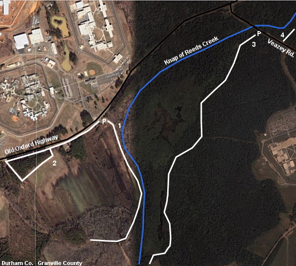
Knap of Reeds Creek Waterfowl Impoundment: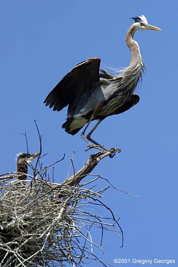
Park in the gravel lot opposite the prison (P). The brushy areas around the parking lot can be fantastic; there was a singing Lincoln's Sparrow here in April 2008 that stayed for several days. The main trail (1) starts beyond the gate. Squeeze past the gate and follow the trail. The trail, which has mature hardwoods and Knap of Reeds Creek on the left, fields and lots of young willows and other second growth on the right, has excellent birding, abounding with warblers, Indigo Buntings, and sparrows. Sometimes a Rusty Blackbird flock is here in the winter. The trail continues for perhaps half a mile to a swampy area surrounded by hardwood forest. Excellent for Winter Wrens (in winter) and a wide variety of land birds such as woodpeckers, nuthatches, and warblers. Red-headed Woodpeckers are fairly common as are Yellow-throated Warbler, Common Yellowthroat, and Northern Parula. The trail continues to a fork. Take either branch of the fork and follow the trail a short distance to the end, then retrace your steps. Both have great birding at all seasons. Retrace your route back to the entry gate. The total length of this trail is about a mile one way.
Back at the parking lot, continue south along Old Oxford Highway about half a mile until you can turn left on a dirt road (2). This leads to a large field with long hedgerows and some swampy spots which rarely hold shorebirds. The field often has a few Savannah Sparrows in winter. Lincoln's Sparrow has been found here on the spring count, right on the Granville/Durham county line. Follow the dirt road, exploring the field as you wish, until it returns to Old Oxford Highway. Return along the highway to the parking lot.
Knap of Reeds Creek sewerline:
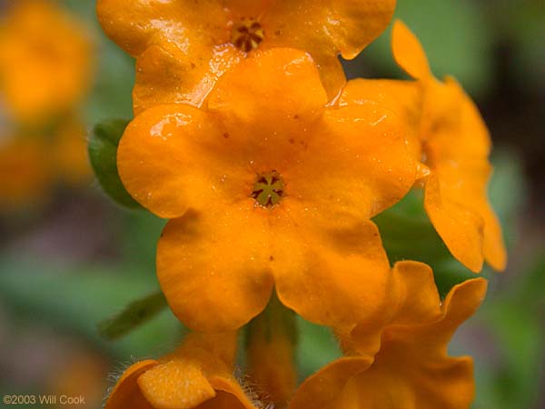
Drive north on Old Oxford Highway for about a mile, then turn right on Veazey Road. In a short distance, you'll cross the bridge over Knap of Reeds Creek. Park on the right (P). Just after the bridge is a gated sewerline path leading southwest (3). Follow the sewerline downstream. In less than a mile, on the right, there's a large beaver impoundment with lots of dead trees. Check for ducks, Red-headed Woodpeckers, and Prothonotary Warblers. Look at the tops of pine trees to see if you can locate the Great Blue Heron heronry. One year a Yellow-throated Vireo built its pendulous nest directly over the trail. Continue along the sewerline as long as you wish, then retrace your steps. Birding is great along the sewerline, and for botanists there are many rare plants to look for, such as Hoary Puccoon (Lithospermum canescens). Coordinates for the entrance to the sewerline are 36 08 34.75 N, 78 47 17.00 W
For those feeling adventurous... if you continue far enough, you'll come to a large field on the left. Follow the field edge trail for a short ways until you get back to the sewerline. At this point, the sewerline turns left and becomes a broad grassy path. Followed this to... (surprise, surprise) a sewage treatment plant. Walk around the plant's fence to the right until a gravel road emerges out from the fence towards Knap of Reeds Creek. Followed this to the creek, then turn left (downstream) and follow the creekside trail. Eventually the trail it becomes narrow and overgrown, but still followable. The trail seems to keep going on forever. Distance back to the car from the sewage plant is probably about 3 miles. See also: trek into the heronry.
After you've explored the sewerline to the southwest, you can walk a little further up Veazey Road, cross the road, and explore the sewerline to the northeast (4). It seems to continue for miles; I haven't reached the end.
Facilities: None
When to visit: Any time of year, though fall through spring are best. During hunting seasons, especially deer gun season (generally Nov.-Dec.), this area is best avoided except on Sundays.
Revised 12/12/08 cwcook@duke.edu
Triangle Birder's Guide home | Chatham/Jordan Lake | Durham/Falls Lake | Orange | Wake