By Will Cook
Overview: On 13 September 1998, I did some exploring at Falls Lake, hoping to find some mudflats where Knap of Reeds Creek enters the lake. I did find some mudflats with a few of the usual shorebirds, but this looks like it could be an excellent birding spot in winter and spring.
The expedition: It's a lot simpler to describe how to get to this spot than to actually get there. The first area I visited was from the Brickhouse Road section of the Butner Game Lands. Take Old Oxford Hwy northeast from Durham and turn right onto Brickhouse Road. Drive 2.5 miles to the gate at the end [coordinates for Google Earth: 36 06 21.5 N, 78 48 13 W]. Follow the main road past the gate, several farm buildings, and a few fields until you get to a large powerline. Turn left at the powerline and follow it to the marshes. Continue east through the sedges and Polygonum until you get to Knap of Reeds Creek (that's the tricky bit). I got to the marsh around 11 am -- after the dew had dried off. I would have been totally soaked if I'd tried this earlier.
There's a beaverdam running under the powerlines that you can follow into the marsh. As I walked past the beaver lodge I heard some excited scrabbling inside. On the left, across the beaver pond, you can see the (Great Blue) heronry that Randy Emmitt and I found (by canoe) this summer. No herons are left on the 9 nests, but they were teeming with young'uns when we were there before. I think the floating mats of vegetation in this pond are probably Ludwigia uruguayensis, an introduced plant in the Evening-Primrose family (Onagraceae) with large yellow flowers.
On the right is a large area of various sedges and Polygonums with scattered dead and live trees, mainly Black Willows. It's a challenge getting through this area, but it can be done (since I'm still here to tell the tale). It's especially fun with a scope on your back. I bet this area is loaded with sparrows in the winter. It looks like a good place for rails and ducks to hide out, too. Eventually you'll get to the edge of Knap of Reeds Creek. The footing is much better here and there were a few mudflats with a few of the usual shorebirds. There were plenty of Wood Ducks, Mallards, and Blue-winged Teal in the creek. Several hundred Chimney swifts circled high above the swamp, with a dozen Turkey and 7 Black Vultures. Shorebirding on the other bank of Knap of Reeds might be better, if you can figure out how to get there. I also saw some good butterflies -- 6 Dion Skippers and a Gulf Fritillary--and hordes of interesting-looking dragonflies.
I tried to go south (right) along the shore, but was soon blocked by densely packed dead willows. I headed back north (upstream) for a ways, then turned to the left, heading towards the heronry. I eventually made it under the heronry, but it was very tough going, plowing through 5 foot tall dense vegetation. I wouldn't recommend it! I found a man-made dike on the north side of the area and followed that west back to the woods. This was pretty difficult, too, because of all the Hurricane Fran trees blocking the path. When I got to the woods, I continued due west through the woods, coming out on the driveway of the last house on the left side of Brickhouse Road before you get to the gate.
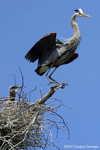
I wanted to try to get to the other side of Knap of Reeds, so I drove back out to Old Oxford Hwy, turned right, drove past the prison, turned right onto Veazey Road, and pulled off just after the bridge over Knap of Reeds Creek [Coordinates for the entrance to the sewerline are 36 08 34.75 N, 78 47 17.00 W]. I followed the sewerline road downstream. In less than a mile, on the right, there's a large beaver impoundment with lots of dead trees. The heronry that Franchesca Perez and I found last year is still there -- I counted 20 nests . There were about 3 youn'uns per nest this spring, but no herons around now (photo at right was taken in May 2001 by Gregory Georges). I continued on to the place where we always stop on the spring count -- where the sewerline crosses a creek (10 feet up in the air) and enters the woods. I pressed on, following the sewerline across a couple of dry streambeds, through a forest of saplings. When the sewerline came close to the edge of the field, I followed the field edge trail for a short ways until I got back to the sewerline. At this point, the sewerline turns left and becomes a broad grassy path. I followed this to... (surprise, surprise) a sewage treatment plant. I walked around the plant's fence to the right until a gravel road emerged out from the fence towards Knap of Reeds Creek. I followed this to the creek, then turned left (downstream) and followed the well-maintained creekside trail. Eventually, where the trail is blocked by some Fran trees, it becomes narrow and overgrown, but still followable. I continued on through some 4' tall lush stands of Laportea (a nasty stinging nettle). The trail seemed to keep going on forever, with no lake in sight, so I turned back. It took me 52 minutes to retrace my steps back to the car (without stopping), so the distance was probably about 3 miles. This area looks like it could be great for birding, but I didn't see much --possibly because it was mid-day and over 90 degrees. I did see a turkey dust wallow, a few deer, a huge snapping turtle, and nearly stepped on a Black Rat snake. If your goal is to get to some mudflats, I think I'd take a different route! I don't think I got as far as the spot where Randy and I saw the Mississippi Kites, which was as far up the creek as we could paddle.
Revised 12/12/2008 cwcook@duke.edu
Triangle Birder's Guide home | Chatham/Jordan Lake | Durham/Falls Lake | Orange | Wake