By Will Cook and Norm Budnitz
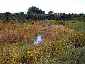
Overview: This section of the extensive Butner Game Lands at the upper reaches of Falls Lake has great birding potential, with open skies for hawk-watching and large numbers of sparrows in winter: Song, Swamp, White-throated, Field, Fox, Savannah, Chipping, White-crowned (in descending order of abundance).
Similar to the nearby Brickhouse Road impoundments, this area is made up of a variety of habitats - swamps, ponds, river bottom forests, and extensive fields with hedgerows - that harbor many bird species throughout the year. Raptors include all the usual NC resident species, plus some of the more unusual species like Bald Eagles and Northern Harriers. In winter, this area abounds with sparrows. The swampy areas are good for woodpeckers and warblers. Since this area is not birded as frequently as Brickhouse Road, there is not a long list of rarities, but it looks like the sort of spot where anything could show up.
One important caveat for birders: This is a game land that has been established and is managed for hunters. It is therefore advisable to restrict birding activities to Sundays during hunting seasons.
Getting there: (mileages in parentheses note landmarks or possible other stops):
|
| ||||||||||||||||||||||||||||
Address for Google Maps: 6450 Old Oxford Hwy, Mangum, NC
Coordinates for Google Earth: 36 07 39 N, 78 49 56.5 W
Where to go: The map below was traced from a satellite photo, so it is precise. To give you an idea of the scale, the distance along Old Oxford Highway from the Flat River parking area to Brickhouse Road is 1.1 mile. If clear background of the map prints off as black, try using Firefox instead of Internet Explorer.
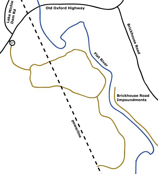
Birding the area is fairly straightforward since there's one main loop and one other trail. Cross the gate and head down the gravel road (brown on map) to the fork in the road. Head right. Cross under the large powerline and continue to the next fork. At this point, you can either turn left to complete the loop or turn right. The right fork is a one-way gravel road, but you can make it a loop (if the ground isn't too soggy) by following the large powerline back to the main road. The entire area is excellent birding - which path you choose usually depends on how much time you have. If you enjoy bushwhacking, there are many other areas to explore off the main roads.
Facilities: None
When to visit: Any time of year, though heat is an issue in the summer. During deer gun season (generally Nov.-Dec.), this area is best avoided except on Sundays.
Revised 12/28/08 cwcook@duke.edu
Triangle Birder's Guide home | Chatham/Jordan Lake | Durham/Falls Lake | Orange | Wake